
Posted on 25/04/2018 by David
As well as height, Snowdon's got size. It's big. This is great news for walkers and adventurers because it means there are many routes to the summit.
All the routes have a unique character to them. Many are well-known, and justifiably popular. Others are less walked.
One route we're going to describe might give you Snowdon all to yourself. Mostly.
So lace-up those walking boots and let's explore England and Wales's highest mountain.
1. Llanberis Path, 4.3 miles, 3,100ft ascent
The path from Llanberis is one of the 'easiest' ways to walk to the summit. It's easier in relation to the mountain's other routes, but it's still a serious trek.
The path is one of the mountain's longest, almost nine miles there and back, following a gradual ridge from the village which gives it its name.
Experienced hikers describe this path as the most dull way to get to the summit, but don't let that put you off. There's nothing dull about walking up Snowdon from any angle.
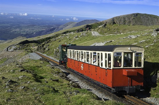
It also has the added novelty value of the Snowdon Mountain Railway following its route for most of the way.
2. The Ranger Path, 3.7 miles, 2,936ft ascent
Off the A4085 on the shores of tranquil Llyn Cwellyn, the Ranger Path zig-zags up a steep hillside towards a pass between Moel Cyngorion (one of Snowdon's many lesser peaks) and the fearsome rising cliff face of Clogwyn Du'r Arddu.
There are more zig-zags as you follow this broad ridge towards Carnedd Ugain, before tracking south and joining the Llanberis Path for the final push to the summit.
This path is one of the least popular on Snowdon, perhaps because it is difficult (but by no means impossible) to use it as part of a circuit.
If you're fit enough, you can combine it with the Rhyd Ddu path by using the Welsh Highland Railway to join the two.
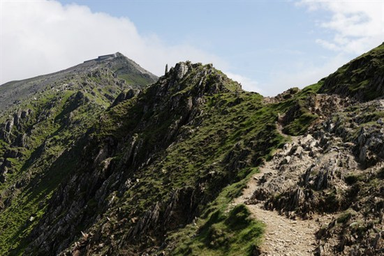
3. The Rhyd Ddu Path, 3.7 miles, 2,821ft ascent
Further along the A4085 towards Beddgelert, this path starts from the Welsh Highland Railway station at the tiny mountain village of Rhyd Ddu (it boasts a good pub, though).
It's increased in popularity recently and the car park, shared with the railway, fills quickly. Follow an old track towards a slate quarry before turning left and heading up the broad, scree-laden ridge of Llechog (not to be confused with another Llechog later!).
The ridge narrows to Bwlch Main, where you need a head for heights, before opening out again for the last, rocky clamber to the summit.
You can turn this route into a circuit by returning via Allt Maenderyn (often referred to as the South Ridge), back to the slate quarry and then back along the track to Rhyd Ddu.
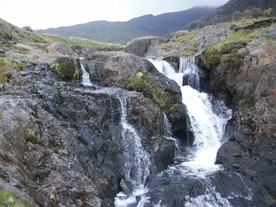
4. The Watkin Path, 3.7 miles, 3,281ft ascent
Starting at just over 50 metres above sea level, walking the Watkin Path from Pont Bethania in beautiful Nantgwynant Valley gives you the greatest climb.
The path is stuffed with features, from old tramways, waterfalls, a giant rock from where Prime Minister William Gladstone gave a speech on Justice for Wales, and even a cemetery.
The path gets tricky near the summit, an awkward crest over scree that needs careful footing and a head for heights. Don't walk this route in icy weather.
The path joins the higher reaches of the Rhyd Ddu path. Again, using Allt Maenderyn and an easy walk back to the Watkin Path makes a circuit possible.
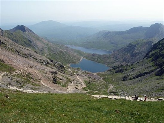
5. The Miners Track, 3.7 miles, 2,509ft ascent
One of the more difficult concerns for hikers on the Miners Track (and the Pyg Track) is getting to the start!
Pen-y-Pass at the top of Llanberis Pass has limited parking. Many park down near the Pen-y-Gwyrd Hotel and follow the road or a path to the start, but take heed of the Clearway signs recently erected - you will get a ticket if you park on the road here. Your best bet is to park down in Nant Peris and grab the Sherpa bus to Pen-y-Pass.
From here, the level surface of the Miners Track can lull you into thinking you're in for an easy walk. After crossing Llyn Llydaw the path reverts to a mountain track, passes Glaslyn and then joins the Pyg Track at the foot of the notorious zig-zags.
A popular option is to make a circuit of the Miners Track and the Pyg Track - more on which, next...
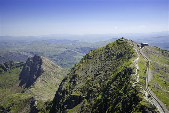
6. The Pyg Track, 3.1 miles, 2,313ft ascent
Starting from Pen-y-Pass, the Pyg Track keeps north of Carreg Gwalch with views down Llanberis Pass before winding through Bwlch-y-Moch, where a stile marks the start of the Crib Goch knife-edge ridge walk.
The rough path skirts the northern base of Crib Goch before the Miners Track joins from Glaslyn below, before the start of the zig-zags. Although well surfaced, this section of the path is dangerous in icy weather.
The path emerges on the ridge just shy of the summit, joining the Llanberis Path for a short hop to the top.
As well as making a loop using the Miners Track, the Pyg Track can also be a return route for fearless climbers on Crib Goch.
7. The Snowdon Horseshoe (Crib Goch and Y Lliwedd/East Ridge), 7 miles, 3,589ft ascent
One of the most spectacular walks in the UK, if not Europe.
The usual way is to start from Pen-y-Pass and follow the Pyg Track and then hike up Crib Goch. This knife-edge ridge (arete) is not for the feint hearted. Some people are reduced to a crawl!
You pass the pinnacles on your way to Carnedd Ugain then onto Snowdon summit. Next, horseshoe walkers follow the Watkin Path down to Bwlch y Saethau (Pass of Arrows) before climbing up onto Y Lliwedd. This is another sharp ridge, though more precipitous on one side than the other.
Following the cliff edge, you drop down to rejoin the Miners Track and head back to Pen-y-Pass, exhausted, exhilarated, and proud to have conquered Wales' most fearsome walk.
8. Snowdon Mountain Railway
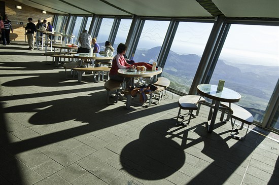
From the most difficult route on Snowdon to the easiest of them all. Let the train take the strain! Or more properly, let the rack-and-pinion railway take you from Llanberis all the way to Snowdon's summit cafe.
The train has been running for more than 120 years. The early carriages had curtains instead of windows. Today the carriages are mostly very new with panoramic windows giving fabulous views all the way up.
It takes an hour to reach the summit. Many people choose to take the train up and then walk back down the Llanberis Path. Don't underestimate the walk down, though. It's tough on ankle and knee joints!
9. Moel Eilio/Llechog ridge loop, 11.2 miles, 5,020ft ascent
Many walkers lament the numbers of people that visit Snowdon. It's true that on some days, all the major paths can be very popular. But not this one!
You need to be fit for this - you'll be walking 11 miles and gaining a total height of 1,500 metres.
Leave the centre of Llanberis and follow the lane leading to the youth hostel. Follow it to the end and stay on the rough track as it heads right. When you reach a stone wall, turn left, go over the stile and follow the steep slope to the summit of Moel Eilio.
From here you'll follow a ridge that takes in Foel Gron, Foel Goch and Moel Cyngorion. Turn right, and follow the cliffs down to down to Llyn Ffynon y Gwas, then pick up the Snowdon Ranger Path to the summit.
For your descent, follow the Llanberis Path for the start but head for Carnedd Ugain (where you'll join Crib Goch scramblers). Keep to the right with the cwm far below.
You'll need to rejoin the Llanberis Path again just before Clogwyn station but shortly after you can head right and follow the grassy Llechog ridge until you rejoin Llanberis Path by Derlwyn (just short of the village).
With so many routes to choose from, which is your favourite route up Snowdon?
Images courtesy: various Visit Wales Crown Copyright 2018. View of the Pyg Track zig-zags from the Llanberis Path, by Rob Young via Wikimedia Commons. Waterfall near the Watkin Path, and Bwlch Main Ridge on the Rhyd Ddu path © Copyright Peter Trimminand licensed for reuse under the Creative Commons Licence.