
Posted on 22/02/2017 by David
Eryri: ‘Land of the Eagles’, ‘Land of the Mountains’ or ‘Snowy Peaks’? The origins of the name Snowdonia are often disputed, but whatever the meaning behind the name, one thing remains forever unquestioned - just how breathtaking the landscape is here.
Dramatic whaleback ridges rise from the sea and the sharp, angular peaks of Snowdonia dominate the landscape for miles. The land is steeped in myth and legend, almost every feature of the landscape has a name linked to tales of celtic folklore.
This blog focuses on the centrepiece - the ‘jewel in the crown’. The world's busiest mountain... the dominating peak of Snowdon itself.
Read on and discover three dramatically different walks to the summit, ranging in difficulty from 2-5 (5 being very challenging).
A note on the weather
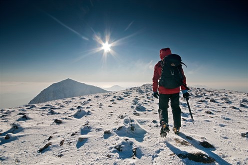
One cannot stress enough that no matter how moderate the weather may seem at lower levels, the mountains of Snowdonia are renowned for changeable weather.
There is a marked temperature drop at altitude, owing to the relentless south-westerly wind sweeping across the Irish Sea. Whilst you may be basking in mild 20 degree sunshine on your ascent, the temperature felt on bare skin at the summit of Snowdon would barely be above freezing - so go well prepared!
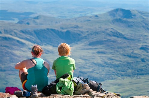
The main routes to the summit can get incredibly busy, which can somehow detract from the experience of being in the heart of the wilderness. So, the first route is for those who prefer a more solitary experience.
Rhyd Ddu and Snowdon Ranger Circular Route
Difficulty: Moderate (4)
Distance: 10 miles
So, it’s a clear, sunny day, you’ve managed to find a parking space, you’re kitted up and ready to go. This route combines two of the quieter paths to create a circular walk. It'll leave you feeling like you’ve achieved something a little bit more special than to have merely ‘done Snowdon’.
The starting point is the railway station at Rhyd Ddu. Walk from there, across the railway line and follow the signposted path all the way to the summit.
The route begins with a gentle climb and after exactly one mile you need to take a left at a junction of paths. You’ll see the steeper sections ahead of you, but don’t worry there are plenty of grassy areas to rest and take in the view.
Llechog, the ridge which curves down from the summit through Bwlch Main, forming the lip of the deep bowl of Cwm Clogwyn looms above. That in itself is a dramatic sight, but as you climb higher, even more stunning views emerge behind you.
The narrow ridge of Bwlch Main is possibly the highlight of this route. It makes an exhilarating, but safe, final ascent to the summit with amazing views in all directions - sometimes you can see as far as the Irish Wicklow mountains.
The descent on the Snowdon Ranger path is less dramatic and meanders down the mountain with only a few sections that are steep.
Further along the Snowdon Ranger Path you’ll find some A-frame steps to your left. Ahead of you you’ll see a disused slate quarry and a lake and just in front of that lies your starting point - Rhyd-Ddu car park.
The final two miles look easy, but the ground can be very boggy so watch your step and ensure you’ve got waterproof footwear!
Pyg and Miners Track Circular Route
Difficulty: Easy (2-3)
Distance: 7.3 miles
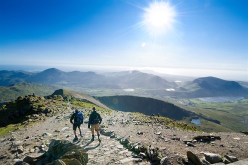
This is the shortest ascent of Snowdon without too many steep sections to endure. A good route for beginners, it still offers all the drama - as the cliffs of Crib Goch and Y Lliwedd loom either side, but is a much more manageable walk for the less experienced hiker.
The path is well signposted, starting behind the café at Pen y Pass it heads west directly towards the dominating eastern ridge of Crib Goch.
The route takes you directly through the basin of the Snowdon Horseshoe and offers fantastic views of Crib Goch, Y Lliwedd and Crib y Ddysgl.
The final ascent to the summit zigzags steeply up the mountain with Garnedd Ugain on your right. This section can be challenging compared to the previous sections, but you’re almost there! It can get quite busy near this point as many of the paths intersect just before the summit.
The descent of this circular route, takes you down the popular Miners Track. The Miners Track offers a marginally longer walk back, but lower in the cwm. It runs directly alongside the lakes below.
When you are ready to descend, head north for 300m and look for the standing stone which signposts Pyg/Miners track. It is the same steep zigzag section as you took on the way up, so watch your footing.
Soon, the path will split again at another standing stone. Take the path on the right which takes you down a scree slope and around the lakes of Glaslyn and Llyn Llydaw.
The last kilometre or so of this route treats weary walkers to impressive countryside views and the southern slopes of the Glyders directly ahead.
The Watkin Path
Difficulty: Hard (5)
Distance: 8 miles
Considered to be the most challenging of the six ‘classic’ routes to the summit of Snowdon, the Watkin Path starts just a few metres above sea level and offers the biggest vertical ascent.
With some tricky sections of steep and loose scree, the final approach to the trig point is demanding and an accident blackspot, so approach it with caution..
Your starting point is just over the road from the car park at Bethania. Head through the gate and follow the waymarked Watkin path. There is a wonderful start to this walk, as the first 2km takes you through woodlands and past the waterfalls of Cwm Llan.
After this the real ascent begins, steadily at first, up to Gladstone Rock and past the disused quarries, then north, rising with the slopes of Y Lliwedd on your right. Be sure to keep to the path on the left.
The next section requires steady nerves! The route takes you along the ridge for almost a kilometre. If you have a head for heights you can peek over and see the ridges Crib Goch and Garnedd Ugain, the lakes below and the Pyg and Miners Tracks too.
The final section is the trickiest part and it requires focus, so make sure you’ve had a rest break beforehand. It is very steep, with loose scree underfoot - use the boulders as hand grips.
You’ll join the end of Bwlch Main ridge, where you’ll join the Rhyd Ddu route for a final (and brutal) push to the summit. The descent follows the exact route - but can be much more treacherous with weary legs.
Snowdon is an incredible and unique mountain which offers such a variety of terrain for hillwalkers of all experience levels (and it has a cafe at the top!).
Hopefully, one of these walks will suit your ability - but if you are completely new to hillwalking, we’d advise taking a guided walk before attempting any of these routes alone. Try Climb Snowdon or Summit To Savour, where you’ll be guided by an experienced mountaineer and can enjoy the mountain safely as you gain confidence.
Images: © Crown copyright (2010) Visit Wales, all rights reserved.