
Posted on 18/10/2017 by David
It's ironic that the mountain range most visible from the A55 is one of the national park's least visited.
The Carneddau Mountains form an unbroken spine of hills rising to the peaks of Dafydd and Llewelyn; the latter's 1,064 metre-height just 21 fewer than Snowdon. True, these twin Goliaths attract a good deal of foot traffic from Ogwen Cottage below, but not on the scale of the more celebrated Glyders and its shark fin outcrop, Tryfan.
Head north from Llewelyn and you'll frequently have the mountains to yourself. Well, almost, as you'll find out in this post!
From Aber to Ogwen - the Carneddau in one
Eight-to-nine hours: Hard (do not tackle when the cloud is down or forecast to come down).
Ideally you need to play the two-car trick to tackle this linear walk. Park in the small car park at the end of the lane leading to Abergwyngregyn waterfalls and then drive all the way round to Ogwen. That's a trek and we haven't even started yet!
Park in the eastern most car park at the foot of Tryfan and then follow the A5 in the direction of Capel Curig. Turn left at Glan Dena and ahead you'll see the valley to the right of Pen yr Ole Wen into which you will walk.
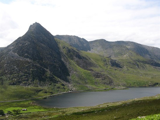
Follow the flagged path and then the route of Lloer River (often in spate!). The shark-fin shape of Tryfan is quite striking from here.
Where the path branches left, follow this to a gully in the cliff. There's a short section of easy scrambling here. Beyond this the path becomes obvious as it rises to the top of Pen yr Ole Wen. Crest to the right for the peak of Carneddau Dafydd, and then another, longer ridge to Carneddau Llewelyn.
From here on you could well find yourself wandering alone - except you may also have wild ponies for company. They're rounded up each winter but otherwise are left to roam the big, grassy slopes of northern Snowdonia.
From Llewelyn follow the broad, grassy ridge to Foel Grach and then Carnedd Gwenllian (used to be Carnedd Uchaf and may still be on your map).
From here, if you have the time and the legs, you can branch left and explore the rocky outcrops of Bera Bach and Bera Mawr (oddly, Bach is higher than Mawr, even though Bach means "small" and Mawr "big" in Welsh!).
Otherwise branch right for the peaks of Foel Fras and Drum before joining a track and contouring down and to the right, back to the car park where your first car awaits.
Yr Elen and Mynydd Du Loop from Gerlan
Seven hours: Hard (do not tackle when the cloud is down or forecast to come down).
One of our favourite walks in Snowdonia! Apart from the peaks of Llewelyn and Dafydd (and the ridge between the two), you will likely have this walk to yourself.
The route down Mynydd Du is a broad, grassy delight with unbeatable views to the Glyders on your right and Anglesey ahead. That's for later, though. Let's head for the start!
The first part of this walk is one of the most challenging - finding somewhere to park. Head for the higgledy-piggledy village of Gerlan above Bethesda.
The footpath follows the Llafar river and you can follow it from Braichmelyn or Gerlan's "main road". About a mile out from Gerlan you need to cross the river.
There is no foot bridge so you are looking for a point narrow enough to jump. Of course, the higher you follow the river, the easier this feat of athleticism becomes!
The next part of the walk is indistinct but you need to head north east over generally forgiving grassy terrain and start to climb Yr Elen (962m). As you reach the summit you will likely stumble across the path.
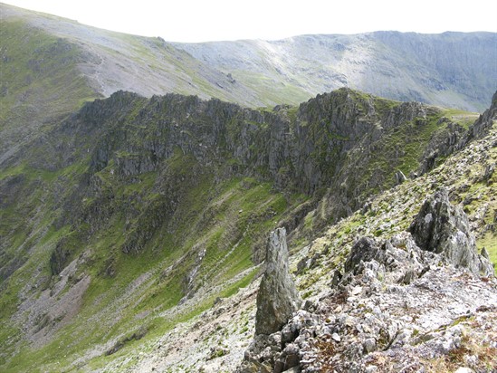
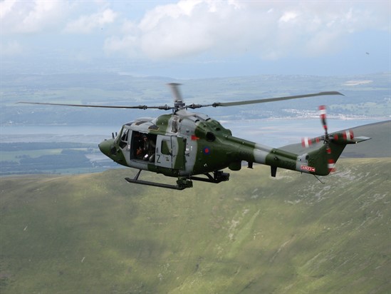
Once you've explored Yr Elen's curiously flat top (often used for rescue helicopter landing practice) it's time to follow a terrific ridge from Elen to Llewelyn's summit. Now follow the long but dramatic ridge to Carnedd Dafydd.
From Dafydd, most people head for Pen yr Ole Wen and down to Ogwen Valley. You're going off-piste instead!
Follow the obvious, broad grassy shoulder of Mynydd Du to the north west and enjoy this lovely, gradual descent back to Gerlan and your car.
Stone Circle and sea views
Four hours: Moderate.
This shorter, linear walk makes a great half-day out. Start from Nant-y-Pandy in the hills above the seaside village of Llanfairfechan. You can park along the road that leads to Nant-y-Coed Nature Reserve, itself a wooded glade well worth exploring.
Instead, follow the road uphill (Newry Drive) until you reach a path on the right (near Plas Heulog). Follow this path uphill as it becomes the North Wales Path; the views of the coast from up here are wonderful.
Now follow the obvious path east. Look out for the wild ponies as this is one of their favourite stomping grounds.
Close to the summit of Moelfre (435m) you'll find the remains of a stone circle. It's hard to distinguish! There are lots of stones strewn about this grassy landscape, all of which look like they could have had some significance to man in times past.
The next stone circle is more obvious and this is a great spot for a picnic, assuming the weather is being kind. Continue on for the remains of two more stone circles.
Now you're high above Penmaenmawr. To your left you'll see the distinct summit of Foel Lus (362m). Follow the North Wales Path as it contours round then bear right for the obvious path to the summit. The views here are sublime!
From this point simply retrace your steps back to Llanfairfechan.
Do you love love the lesser-explored Carneddau Mountains too? Share your favourite walks with us on Facebook or Twitter.
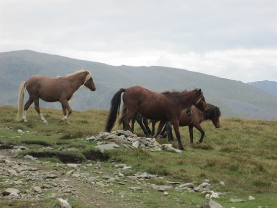
Images courtesy: Carneddau ponies © Copyright Peter and licensed for reuse under this Creative Commons Licence. Ridge from Yr Elen to Carnedd Llewelyn, Tryfan from the path near Afon Lloer, Helicopter training at Yr Elen, by Phil Thomas.